


|
This section contains all data & maps created throughout the planning process. Click the image to view more details. |
|
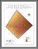
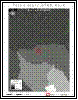
This image displays elevations across the tract using contour lines as well as a sequential color scheme. |
|
Tract Contour Map |
|
This image displays the natural drainage pattern of the tract using dark lines to represent potential stream channels. |
|
Tract Drainage Patterns |
|
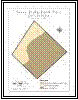
This image displays the basin which encompasses the tract, as well as nearby stream channels. |
|
Basins & Streams |
|
This image displays the scenarios which will impact the runoff accumulation in the park tract. |
|
Runoff Impact Scenarios |
|
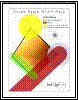
This image displays the channels and detention ponds of the conceptual drainage system design. |
|
Drainage System Design |
|
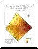
This image displays the soil type, quantity and distribution throughout the 38 acre tract. |
|
Tract Soils |
|
Data & Maps (Page 1)
|
|
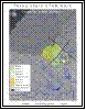
No Build Zones |
|
This image displays no build zones for different features within the tract. |


|
Texas State University — Texas STAR Park |