Local Hazard Mitigation Site Plan City of San Marcos, Texas
Summary
With an accelerated increase in population in the City of San Marcos, TX there is a necessity for a WebGIS site plan for hazard mitigation. Additionally, climate change is simultaneously escalating natural hazards and their consequences that occur around the world. Natural hazard mitigation allows for the reduction or elimination of risk to life and property. Through collaboration with the City of San Marcos, TX we have created a site plan, concise descriptive text, and an example home page to effectively protect the city. The City of San Marcos provided our group with a draft of the 2024 Hazard Mitigation Action Plan (HMAP). We then utilized this HMAP to generate descriptive text over the city which includes information over aspects such as social, environmental, housing, critical infrastructure, and future growth and development. Moreover, the HMAP was used to produce the descriptive text on each natural hazard the city faces, and we closely followed the subsections within the HMAP. For our two main deliverables, we used a website called LucidChart, to finalize our site plan or wireframes. The descriptive text was analyzed by our entire group and this was assisted by Claude AI. The secondary deliverable, the example home page, was created and published on ArcGIS online. A WebGIS site is ideal to reach and inform the population who currently lives in San Marcos, the population who will potentially move to San Marcos, and prospective business owners. This project will provide the City of San Marcos with a guideline of a natural hazard mitigation site and expectantly influence other cities to follow in their footsteps.
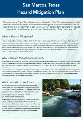
Hazard Mitigation Site Home Page