.png)
Emerald Crown Trail
Data Compilation and
Web Map Development
Summary
The Emerald Crown Trail is a proposed trail network system connecting the municipalities of Hays County, Texas. As the Central Texas region continues to attract more people, there is a growing need for transportation and recreation resources. A web map was created using ESRI Web AppBuilder. The web map was designed to garner community and stakeholder interest and provide a common point of reference for the groups constructing the trail.
Purpose
As the population increases, parks and green spaces will become an important outlet for community recreation purposes. The Emerald Crown Trail strives to unite these spaces by creating a trail network system across the Hays county portion of the IH-35 corridor, creating an ecologically-grounded sense of place in Hays County. It is hoped that the web map will benefit the construction of the Emerald Crown Trail.
Methods
While 12 percent of the 75 miles of the Emerald Crown Trail has been constructed, there is a large portion of proposed and conceptual trails. The completion of the Emerald Crown Trail will be a group effort with multiple stakeholders involved to see the project through to the end. This is where our group, the Emerald Crown Coalition (ECC), comes into the fold. The ECC was tasked with refining data and creating an online interactive web map. The process of making the map was split up into acquiring the data, splitting up the original Emerald Crown Trail shapefile made by the National Park Service among group members, cross-referencing and correcting the shapefile using ESRI satellite imagery to comply with the Emerald Crown Trail master plan, and re-merging the shapefile again. After this, spatial joins and identity functions were performed to add attribute data to the final shapefile. After this, a web map was created using ESRI Web AppBuilder.
Conclusion
Using a variety of GIS tools and processes, we were able to display a refined Emerald Crown Trail shapefile within our web app. In conclusion, Emerald Crown Coalition has edited and refined data in order to create an accurate web app that may be used as a resource for stakeholders and members of the public. While we wish we were able to include more data and attributes, we are glad to have contributed to the overall Emerald Crown Trail process.
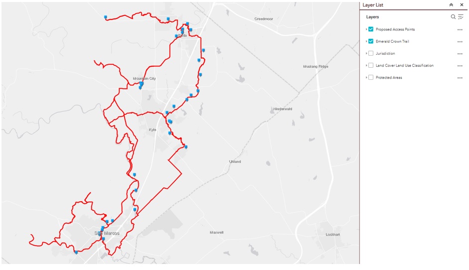
One of the layers on the final map depicting the ECT as well as access points