Project Overview
The City of Austin Urban Forestry Program is interested in exploring the relationship between tree canopy coverage and water quality. Trees in UrBan Areas was hired to provide tools for the client to conduct further research on this issue. The objective of this project is to find the percentage of tree canopy coverage in watersheds associated with water quality testing points.
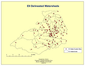
TUBA will begin with a pilot project of one watershed to cultivate a model for delineating a hydrology network. The first step implemented in the pilot model will be to fill sinks and small imperfections in the data. The next step will be creating a raster for each cell showing flow direction to its lowest elevated neighbor. Then, using the determined flow direction, a flow accumulation raster will be created to display accumulated flow to each cell. The final step in creating the pilot watershed will include the flow direction raster output and one EII water station point. All water that falls/flows upstream to this point will be visualized with a raster of the contributing catchment area in the form of a watershed. Next we will overlay the watershed layer with the 2006 canopy layer to determine canopy coverage. These models can then be replicated for as many watersheds as possible within the time constraints of the spring semester.
The final goal of this study is to provide the City of Austin Urban Forestry Department with a usable model to contribute to better land management. Our creation of watersheds from water quality sampling points will enable the client to relate specific sampling points to the amount of tree canopy in their respective watersheds.
Scope of Project