Purpose
The Geo Solutions team understands the key to an economically progressive and viable airport is protecting the land around it and especially the airspace. The safety of incoming planes, as well as the people underneath, is the number one concern. It is for this reason that the City of New Braunfels is in the process of adopting an ordinance to enforce Airport High Hazard Zoning Districts for the area around the New Braunfels Regional Airport. The Federal Aviation Administration created the Airport High Hazard Zoning Districts to limit the height of structures in critical areas around airports. Unfortunately, these zoning districts have a complex geometry making it difficult to calculate the maximum building height at a specified point, and even more difficult to visualize the zones in real life. Our goal was to create visual representations of the restricted airspace zones so they may be easily understood by city staff and the public, which we have delivered.
Methodology
-
3D Model - ArcGlobe
- - Created individulal restriced zone polygons in Google SketchUp
- - Merged those polygons together
- - Imported them into ArcGlobe
- - Created a fly-through video to show an overview of the entire model

-
3D Model - Google Earth
- - Import SketchUp model to Google Earth
- - File can be downloaded from the New Braunfels city website in order for citizens to view the model themselves via Google Earth
- - Import SketchUp model to Google Earth
-
Interactive Mapping Tool
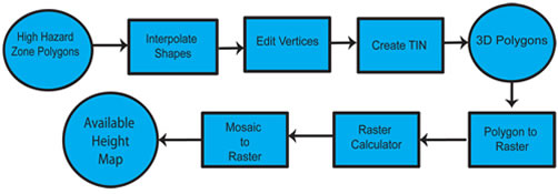
- - Assigning elevation values to the hazard zone polygons
- - Given to us by the City of New Braunfels
- - Calculated the slope for each zone
- - Converted the polygons to 3-D shapes
- - Calculated the maximum building heights (difference betweeen zones and DEM)
- - Assigned a graduated color scheme to display difference in height restrictions.
- - Assigned a graduated color scheme to display difference in height restrictions.
- This tool allows city staff to click anywhere inside the graduated color areas, revealing the maximum building height as a pop-up.
With the raster map, or, interactive mapping tool, city staff can quickly and accurately inform landowners and developers of any height restrictions they may need to abide by. Furthermore, we consider all of these approaches as ways the city can keep within its goal of being proactive as they move forward into the future.