|
– GIS Design & Implementation – Spring 2011 |
|
|
|
Creative Geospatial Solutions Covering over ten counties, the Edwards Aquifer is a principle source of water for Central Texas. It serves nearly two million people and the natural environment including countless endangered and threatened species. In order to aid in the protection of the aquifer, this project, prepared for the Greater Edwards Aquifer Alliance (GEAA), has two main goals: 1) Create a comprehensive map and dataset of wastewater pipelines within the Edwards Aquifer Recharge and Transitions Zones 2) Detect areas of future wastewater infrastructure development This information will be used to help improve connectivity between wastewater service providers within Municipal Utility Districts, and increase transparency of wastewater infrastructure. |
|
|
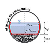
El Grupo de Alcantarilla A geodatabase was developed to catalog and manage information about culverts on TxDOT roadways. These are smaller culverts that are not cataloged by the TxDOT Bridge Inventory Inspection and Analysis Program (BRINSAP). The geodatabase will assist TxDOT in the implementation of an inventory management program and maintenance procedures. |
|
|
Gaillardia Geoconsultants Disc golf is an outdoor sport growing in popularity which can add value to a neighborhood or city. Physical site assessment, ArcGIS, Adobe CS3, and a variety of research methods were used to design a course for the City of Lockhart. A development guide and locational data were compiled to give Lockhart a viable course design that can be implemented presently or in the future. |
|
|
Geospatial Pet Solutions The purpose of this project was to gather, interpret, and map data regarding AHS operations and demographic s for: dog and cat adopters, sources, volunteers, donors, and collaborators. The results of the project will help AHS work more efficiently and effectively to save homeless animals in central Texas and educate the public on responsible pet ownership. |
|
|
3 Dimensional Geovisualization
SQUAD By collaborating with the City of Lockhart, the 3 Dimensional GeoVisualization SQUAD (D^3GVS) has created a three-dimensional model of Downtown Lockhart, TX. As State Highway 130 nears its expected completion (in 2012), the City of Lockhart is anticipated to experience both financial and residential growth. D^3GVS used free, open-source software such as Google SketchUp 8 and Microsoft Photosynth. The 3D model of Lockhart D^3GVS has generated will be integrated with Google Earth and displayed as a web application on the City of Lockhart website. |
|
|
|
|
|
|