San Marcos Trail Mappers
Summary
San Marcos Trail Mappers will create digitized features for Reimer’s Ranch and Muleshoe Bend to enable Austin Ridge Riders to better document the biking trails, multi-use trails, and other important features in those areas. These maps can then be used to create simple maps for use by bike riders as well as to create more complete maps to be used by Austin Ridge Riders to plan and maintain the trails. To do this, open source GIS such as Google Earth and QGIS were used in conjunction with existing maps to make shapefiles of the features in the study area. From that data, simple maps were created in a manner that are easy use as reference maps by bikers riding the trails, and complete maps will be given to the club for trail planning and maintenance. We will provide PDF maps and QGIS maps of the areas for use by Austin Ridge Riders, who do not have access to ArcGIS, as well as shapefiles for use in the future if the club does obtain access to ArcGIS software.
Purpose
The maps designed by the San Marcos Trial Mappers were shown to promote trail signage, user friendly maps for the public, and provide sustainably trail options for further development by the nonprofit organization Austin Ridge Riders. More importantly, the maps provided by the San Marcos Trail Mappers will hopefully aid in the organizations main purpose of providing an educational outreach to trail goers in respects of safe and proper usage of recreational biking.
Methods
Using the data given to us by Austin Ridge Riders and other data collected online, we began the process of digitizing Milton Reimer’s Ranch and Muleshoe Bend Recreation Area. 50cm aerial imagery obtained from the Texas Natural Resource Information System (TNRIS) website provided a georeferenced backdrop that we then overlaid with an existing map image of the parks found online. The map image was referenced with the georeferencing toolbar using easily recognizable control points, such as road intersections, evenly distributed across the map image to stretch the image so that it matched the aerial image beneath. Transparency of the park map image was adjusted so both the existing map image and the aerial imagery could be seen at the same time. From there, we digitized feature classes in to the ArcMap document starting with the Park Outline followed by a Roads layer. Then we imported the trail data provided to us by Austin Ridge Riders. The trail data given to us was a point feature class in the GPX format. The file was changed from the GPX format into a shapefile with the GPX To Features conversion tool so it could then be opened, viewed, and manipulated in ArcMap. The point feature class was turned into a line feature using the Points To Line tool. Then we split up the single line features with the split line tool in the editor toolbar into the different trails and classified them by trail name and difficulty. Five-foot contour line data was downloaded from the TNRIS website, opened in ArcMap and clipped using the park outline as a mask. Other features were created including: bathrooms (flushing, non-flushing), mile markers, flood zone, river channel, trailhead, and alternative/emergency access points to the trail. The alternative/emergency access points are located at points where the trail intersects with the park roads totaling four alternative access points. Some of the shapefiles had to be projected so that all the features shared the same coordinate system. The methods for digitizing Reimer’s Ranch and Muleshoe Bend were practically identical except for a few minor edits. The maps were exported as a PNG and brought into Adobe Illustrator where they were further edited for aesthetics and to make them more user friendly. Information such as title, legend, scale bar, and north arrow were among the elements added to the maps.
Conclusion
The Austin Ridge Riders project taken on by the San Marcos Trail mappers will help the club plan and maintain trails in the Reimer’s Ranch and Muleshoe Bend areas, as well as help bikers navigate through the trails. This will result in better overall safety of the trails for bikers of all skill levels. When creating data of an area where there is none, it is important that the data be as accurate as possible. The data that we deliver to our client will be used quite a bit before new data is created. It may also be used by anyone else that needs data for this area. This was the biggest obstacle in our project; that digitizing features accurately without being able to go out and collect GPS data points is very difficult. Digitizing the features of these areas required a great deal of patience to get accurate results. Now that the base maps have been created for these parks, there are many possibilities for future projects. One that may be of best benefit to the Austin Ridge Riders specifically would be to use GPS to pinpoint potential hazards, endangered plants, and other points of interest along the trails to help with trail planning. This way, much of the planning can be done before the group goes out into the field to make changes to the trails, as well as allowing the users to see the potential hazards as a part of the big picture of the trails.
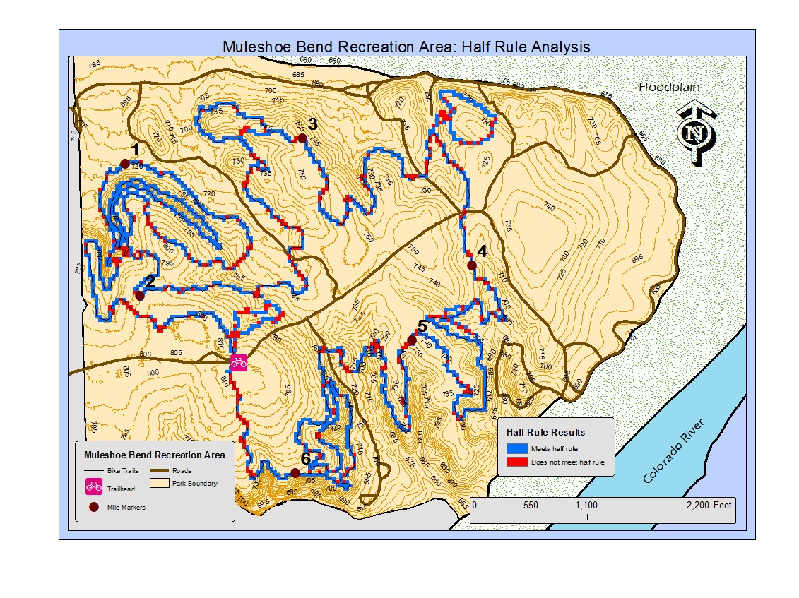
Results from the trail sustainability test for Muleshoe Bend