2.1 Purpose
The purpose of this project was to develop a three-dimensional model of Downtown Lockhart, TX. The model will be used by the city’s Economic Development Coordinator to attract new businesses to Lockhart. The City of Lockhart is expecting to grow as a result of the construction of State Highway 130 (see Figure 1. below). Lockhart is a town proud of their past and beautiful historic buildings. A 3D model will not only entice developers to invest in a burgeoning city, but also preserve a rich history. The GeoVisualization Squad has provided the City of Lockhart with instructions to edit the 3D model. This feature allows the Visualizing Lockhart Project to grow and change as the city develops over time. As the city expands, a 3D model will prove to be beneficial for urban planning.
2.2 State Highway 130
State Highway 130 (SH 130) is a toll road that currently links Georgetown to Mustang Ridge. The new 40-mile stretch of road, which will link Mustang Ridge to Interstate 10 in Seguin, is expected to open in 2012 (mysh130.com, 2011). The goal of SH 130 is to relieve congestion from Interstate 35 in Austin, San Marcos, New Braunfels, and San Antonio by diverting traffic around those major cities. SH 130 will pass Lockhart to the north (mysh130.com, 2011).
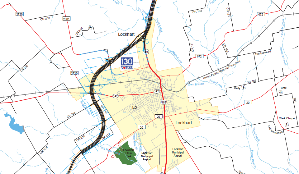 |
Figure 1. Map showing the location of State Highway 130 near Lockhart.
Photo Courtesy: www.mysh130.com
2.3 Anticipated Growth
With a direct route to the growing metropolis of Austin, Lockhart is expected to experience “an investment in the region’s economic vitality” through growth in population, tourism, and economic development (mysh130.com, 2011). This concept is based on the growth that the cities of Pflugerville and Hutto experienced after SH 130 was opened in 2006 (mysh130.com, 2011). As illustrated in Austin Business Journal, Pflugerville has experienced growth as early as 2005 (Kasper, Mary Alice, 2005). A city developer from Pflugerville anticipated 1,700 acres would be added to the small community (Kasper, Mary Alice, 2005). Other areas of growth along SH 130 include Seguin, at the end of SH130. In 2006, an economic development committee in Seguin, received a $14.15 million bond from the city council to fund improvement projects throughout the city (Wallace, First American Commercial Property Group, n.d.).
The potential growth in Lockhart may expedite similar funding for city enhancement projects. A 3D model will be useful in planning and implementing of city improvements. Based on evidence from other small cities along SH 130, Lockhart is likely to experience similar levels of economic and residential growth. This growth will lead to multiple opportunities for adaptive reuse, community involvement, and company investments. Having a 3D model implemented before SH 130 reaches Lockhart will facilitate the growth of more businesses, by allowing business owners to look at potential business locations. Lockhart will still be able to charm visitors with a small-town feel, but with advanced 3D technology.
2.4 Project Benefits
The 3D model will allow prospective business owners, residents, and tourists to visit the city via the City of Lockhart website. This new form of virtual tourism allows consumers to experience a location without incurring travel costs. To encourage manufacturing centers and other industries to consider Lockhart for their new location, the interactive model of Lockhart can be promoted via programs such as Google Earth.
Our interactive 3D model is able to provide an inventory of buildings in Google Earth, once the model has been accepted into Google Earth. Within Google Earth, potential business owners may view open locations. City planners for Lockhart may use the model to highlight areas for adaptive reuse of the downtown area to create parks and recreation areas. The GeoVisualization Squad’s 3D model will aid in the preservation of the heritage and history of Lockhart by showcasing photo-realistic models of the historic downtown area on the internet. Lastly, The GeoVisualization Squad has included a set of instructions that outlines our methodology so that City of Lockhart employees may build upon the 3D model as buildings are added or improvement projects completed.
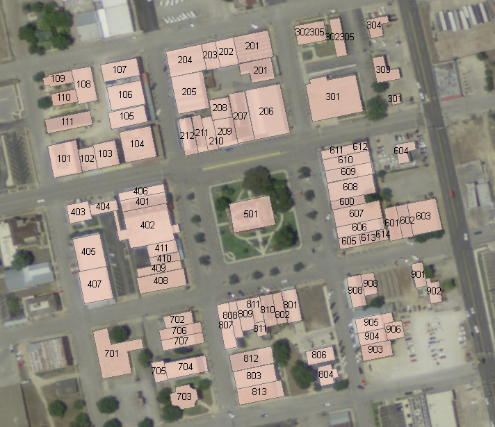
2.5 Scope
|
Figure 2. Building footprints for the project area displaying our arbitrary numbering system used for organizing the data collection and modeling processes.