|
About the Project |
|
Geo-Tex Spatial Solutions |
|
SUMMARY More and more, companies across the nation are turning to Geographic Information Systems (GIS) to distribute information, answer problems, and communicate more effectively - both within their organizations, as well as to the public who seek to utilize the data. One way to share this information is to publish interactive maps, which allow users to access, manipulate and gain specific information via the internet. Often, organizations such as the Guadalupe-Blanco River Authority (GBRA), have a wealth of information available, but no way of visually communicating that information to the public. We have been contacted by the GBRA to create interactive maps for the organization’s web site. This new resource will further accomplish the goal of the mission statement of the GBRA, which is to “protect, conserve, reclaim, and steward the resources” of the water conservation district it oversees. Therefore, giving users a visual representation of the existing resources within the boundaries of the district so those resources may be used responsibly.
PURPOSE The overall purpose of this project is to create web-accessible public interest maps for the GBRA’s web site. The benefits of this project are three-fold. First, we are providing the GBRA with additional public interest maps to be included on its web site. Second, the addition of a GIS component allows the maps to have an interactive content, which lets the maps to be viewed over the internet via user-driven software. Third, developing the maps with a GIS component allows the datasets that were used in the project to be made available on the GBRA’s web site for download.
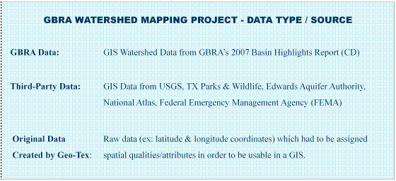
METHODOLOGY In order to produce the final product, it was necessary to undertake a three-stage process, which include: 1) data collection, 2) assembly of collected data using GIS software (Arc-GIS), and 3) conversion of those maps into a web-GIS program – in this case Manifold Software – which will allow the maps to have a user-driven interface via the internet.
CONCLUSION This project will make it easier for users of GBRA website to access valuable information about the recreational resources of the area. |