Green Leaf Counsulting
Summary
The City of Austin Public Works Department has a goal of planting 1,000 trees each year within the full purpose Austin City Limits. While the city has been successfully planting trees, there is no system in place to determine these planting locations and this effort has been driven by public request. The application of a GIS would provide the City of Austin a scoring system for priority areas that are in need of trees being planted. These areas will fit the criteria established to ensure that the locations with the highest need of trees get the most attention.
Purpose
To design a scoring system that will determine ideal locations that the Public Works Department can plant trees. This study will examine planting factors determined by Alan Halter in his Tree Planting Prioritization Report. These categories included public health and safety, air quality, environmental justice, water quality, critical places, forest replenishment needs, tree preservation and development impacts, and urban heat islands. Each of these have multiple factors within them to determine their overall priority score. Other factors that will be determining these locations will be overhead utility interference as well as locations with enough area to plant fifty or more trees, as this is more cost efficient for the city. The areas of focus will be divided among the ten political districts within Austin and within medians along arterial roads. This study will identify the areas within Austin City Limits that will be the most beneficial as well as the most cost effective to plant trees.
Methods
Task 1: Create a criteria to determine ideal tree planting locations.
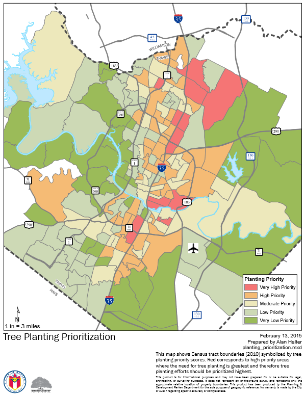
• A tree planting prioritization report (Figure 2) created by a former
employee of the COA, Alan Halter, was used as the most critical
determining factor of locations. • Factors this report took into
consideration included public health and safety, air quality,
environmental justice, water quality, critical places, forest
replenishment needs, tree preservation and development impacts,
and urban heat islands.
• Additional criteria created were that locations needed to be within
medians along arterial/thoroughfare roads, locations needed to be
clear of overhead utilities, areas needed to be large enough to plant
fifty trees or more, and areas had to be in need of more tree canopy
cover.
Task 2: Choose locations.
• Locations were chosen through examination of aerial imagery and
analysis of promising locations. • During this step, ten locations were
chosen.
Task 3: Analysis of ten locations.
• For each location, analysis was performed to determine the tree
canopy cover within 200 feet of the medians.
• This data resulted in a percentage to help the COA easily see which
locations were in most need.
Conclusion
The COA will be able to implement the criteria that has been determined in the future as they continue to strive towards the goal of planting 1,000 trees each year. The ten locations that have been chosen are a good starting point and we hope that our criteria we created will aid in finding more locations in the years to come.
Location of all utility and amenity features located in the Gary Sports Complex