AquaKESKA developed an operational IMS using Manifold software. The interface includes a map with 62 data layers, satellite imagery, a legend, zoom and info tools. Each data layer can be toggled on or off, depending on the needs of the user. Using the info tool, the user can click on an item and see associated attribute data. When the user first opens the IMS, a map of the 17 HCA counties and all the data layers is displayed. The user can deselect unneeded layers to increase the speed of the website, and zoom in to their area of interest. A legend at the bottom of the page helps identify many of the features. A link to the IMS can be found on the AquaKESKA website: http://geosites.evans.txstate.edu/~g4427f07-01/index.htm.
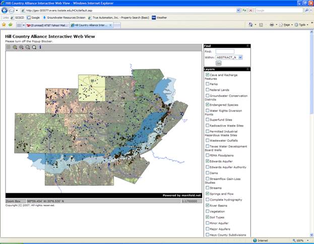
Figure 5. A screen shot of the IMS online. Many of the environmental features of the Hill Country are shown here, including soil class, streams, the Edwards Aquifer, spring locations, and cave and recharge features.
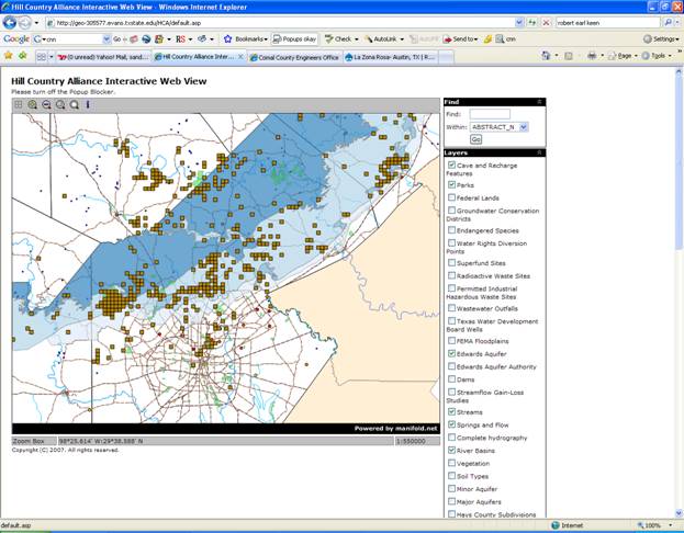
Figure 6. A screen shot the IMS online. The Edwards Aquifer, cave and recharge features, streams, springs and parks are visible over portions of Bexar, Comal, Hays, Kendall
and Medina counties.
1.5.2 Groundwater Vulnerability Model
The results from the slope analysis are shown in Figure 7. Green areas indicate gentle slopes, while yellow and red areas represent increasingly steep slopes. A slope of 50% represents a 30-degree rise. Note that the steeper slopes tend to occur in a band along northern edge of the Balcones fault, with the very steepest being clustered in Bandera, Real, and eastern Edwards counties near the headwaters of the Medina, Sabinal, Frio, and Nueces rivers.
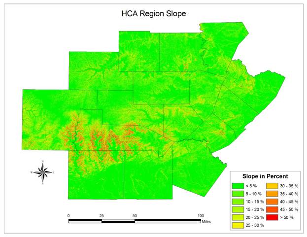
Figure 7. Slope in percent for the HCA region
The final composite raster for the soil component of the GVM is shown in Figure 8. The values are the indexed average of the six soil attributes, with higher (redder) values indicating composite soil characteristics which contribute to greater vulnerability. The areas of greatest vulnerability appear throughout Llano County, and south of the Balcones Escarpment in southern Bexar, Medina, and Uvalde counties. The composite indices in these areas represent high vulnerability correlation in measurements of saturation, CaCO3, organic matter, and clay percentage.
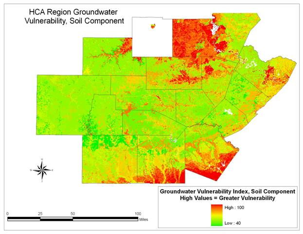
Figure 8. Groundwater Vulnerability for the HCA region
During the data collection phase of the project, TerraCorps discovered that acquiring the needed data from the individual counties was more difficult and time consuming than planned, particularly in comparison to the layers assigned to AquaKESKA. To better distribute the remaining workload, it was decided to combine the datasets and create a unified website. The end product is an IMS with environmental, hydrological, and urban planning data incorporated.
The website will be a new tool available for public use. The hydrologic and environmental data overlaid by the urban layers will help others visualize the effects of a rapidly-growing population on an environmentally sensitive area. This will function as a reference tool for developers, planners, conservationists, and informed citizens regarding the changing ecologic environment of the Hill Country.
The DRASTIC model or a derivative thereof will provide a more precise and scientific tool for assessing the environmental vulnerability of specific areas within the Hill Country, and will assist both developers and planners in choosing the least-vulnerable sites for managing the growth of this region.
Future work might include the addition of predefined queries to the interface. A query can be structured to select a variety of features based on the needs of the user. For example, a query could allow the user to select all parcels within 200, 400, or 600 feet of a stream. A user would access the query from a drop down box in the web interface.
Additionally, refinement of the interface may prove beneficial. Our initial timeline allowed for two-to-three weeks to refine the interface and make it as user-friendly as possible. However, due to the difficulties encountered getting the IMS online (discussed in the next paragraph) we were only able to spend two days on refining the interface. This only allowed for fixing glaring errors and noting smaller problems, but not necessarily fixing them.
The major problem encountered during the project was getting the Manifold IMS online. Due to the nature of the computers and servers accessible by our group, bypassing administrative rights, permissions and servers proved difficult. In addition, a Manifold IMS has never been implemented at Texas State prior to this project. Manifold software served on a single computer provides better access for an IMS designer.
The very characteristics that make the Hill Country so valuable to homeowners and developers – its limestone hills with their scenic views and fresh water sources – also render the area ecologically fragile, and subject to contamination, destruction of wildlife habitat, and general degradation. The level of degradation rises as development increases, particularly when the most vulnerable areas are the ones being developed.
The tools produced by this project will help to divert the inevitable growth of the region towards less vulnerable parts of the Hill Country, thereby maintaining the environmental degradation at a more manageable level and extending the lifespan of this uniquely beautiful and fragile piece of the world.