The Hill Country of central Texas is characterized by hilly terrain, oak and juniper communities, rock outcrops, and natural springs. Rare and unique plants and animals can be found here, and in some cases, nowhere else in the world (Campbell, 2003). The beautiful scenery and small, sleepy towns found in the Hill Country have been a favorite of Texans for decades. In the last two decades, however, the rush of people moving to the Hill Country has threatened to degrade the very landscape that brought residents to the area.
United States Census Bureau data list Hays (54), Comal (70) and Kendall (73) counties in the "Housing Unit Estimates for the 100 Fastest Growing Counties With 5,000 or More Housing Units in 2006: April 1, 2000 to July 1, 2006" (U.S. Census Bureau, 2006a). These three Texas Hill Country counties have all experienced phenomenal growth in the last seven years: Hays County has seen a 31.8% increase between January 1, 2000 and July 2006; Comal County, 29.7%; and Kendall County, 27.3% (U.S. Census Bureau, 2006b). Other Hill Country counties undergoing a significant increase in growth include Travis (13.4%), Gillespie (13%) and Bexar (11.7%).
The Hill Country Alliance (HCA) is a non-profit organization whose purpose is to raise public awareness and build community support around the need to preserve the natural resources and heritage of the Central Texas Hill Country. HCA was formed in response to the escalating challenges brought to the Hill Country by rapid development. The Alliance has participated in regional planning efforts, natural area and water quality bond initiatives and citizen advisory panels.
AquaKESKA was approached by HCA to 1) develop an interactive website for the public to help them understand the vulnerabilities of the Hill Country, and to 2) assist the HCA in developing a model for this purpose.
The primary audience for the interactive website will be planners and developers, who will use the data to make better site planning decisions for future developments in the Hill Country. AquaKESKA provides the natural and environmental features for the website; another team, TerraCorps, supplies a dataset focusing on urban land use in the Hill Country. All datasets are combined to produce the final product.
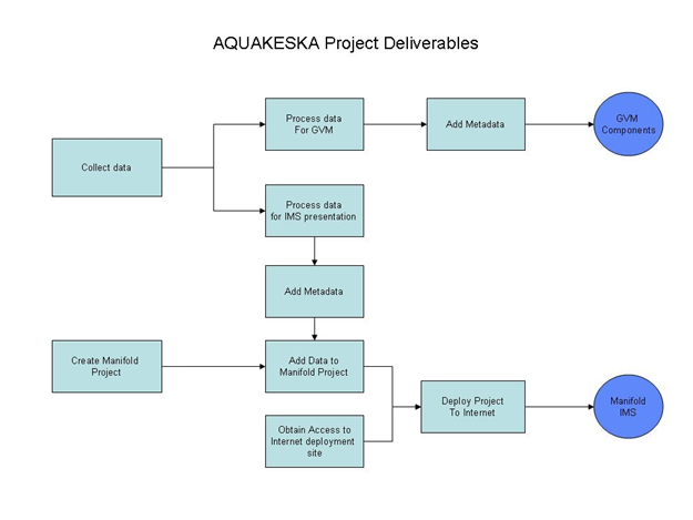
Support for the groundwater vulnerability model consists of providing some of the spatial datasets used to build the model. Once the model is complete, the results will be incorporated into the public website (Figure 1).
Figure 1. Overall Project Workflow
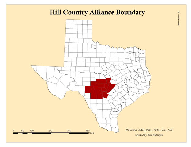
The HCA is concerned with the area covered by the following seventeen counties: Bandera, Bexar, Blanco, Burnet, Comal, Edwards, Gillespie, Hays, Kendall, Kerr, Kimble, Llano, Mason, Medina, Real, Travis, Uvalde (Figure 2). Henceforth the term "Hill Country" will be synonymous with this 17-county HCA area of interest.
Figure 2. Hill Country Alliance Boundary
Geographical Information Systems (GIS) software is a natural choice for fulfilling the requirements of this project. The basic question being answered is geographical in nature: Where are the development-sensitive areas in the Hill Country that should be to address the fundamental issues.
The GIS software vehicle for website delivery is known as an Internet Mapping Service, or IMS. For this project, the selected IMS is Manifold®, although ArcGIS™ will also be used in preparing the data. The primary extension required is Spatial Analyst, which provides the tools to create slope data as well as to process the several soil raster datasets needed for the GVM.
IMS sites are appearing at an explosive rate across the internet, and represent a rich niche for GIS expertise to fill. The following websites have been studied as models upon which to base the design of the HCA IMS:
● United States Geological Survey (USGS) http://nmviewogc.cr.usgs.gov/viewer.htm
● City of San Antonio http://maps.sanantonio.gov/website/DevServices/Run.htm
● City of New Braunfels http://maps.nbtexas.org
The USGS site is a viewer on a national (and in some cases international) scale. There is an abundance of data, but due to the scale of the site, it is not feasible to include many of the environmental features that are requested by HCA. The city websites are more local in scale, but again, many environmental features are missing.
Groundwater Vulnerability Models
There are several existing GIS models which have similar purposes to this study. One model (Hammond, Jr. and Hardberger, 2005) studies population growth, impervious cover, and their impact on the Trinity Aquifer recharge quantities as they relate to precipitation. A recharge probability model was produced using ArcView, and 200-meter grids were generated from these views. Using a rating scheme, each layer was assigned a number based on its recharge effectiveness, with higher numbers representing a larger recharge potential. The layers used in this model include faults and fractures, geology, land use, soil, vegetation, and streams. All of these data layers are relevant to our study and are core data in our research of environmental vulnerability. When examining the environmental quality of an area, hydrologic characteristics are the first considered. Thus, a prior study of recharge potential was valuable during the construction of AquaKESKA's hydrologic model.
In another study (Stone and Schindel, 2002), a GIS matrix was developed and applied to the process of prioritizing sensitive karst lands. First, a vulnerability model showing the areas of highest permeability was created by overlaying a dataset including buffered faults, sinkholes and caves with a geologic classification dataset and a slope dataset. Next, a biological model showing the areas with the highest potential for threatened and endangered species was created by combining a vegetation habitat layer for the Golden Cheeked Warbler (an endangered species native to the ash juniper and oak woodlands of central Texas) with an endangered invertebrate layer using the spatial overlay function. Finally, a comprehensive model was built through weighted overlay which included the vulnerability and biological models discussed previously and also a watershed data layer.
Based on this research, decision makers can determine the public policy necessary to optimize water quality in central Texas. The San Antonio segment of the Balcones fault zone section of the Edwards Aquifer is one of the most productive karst aquifers in the nation and was designated by the Environmental Protection Agency as the first "Sole Source Aquifer" in the United States. It is also the primary source of water for millions of people in central Texas; therefore, scientific research for the protection of water quality in the Edwards Aquifer is important to citizens of the Texas Hill Country. AquaKESKA's goal is to reach residents of the Hill Country and transmit environmental research, including hydrologic data, to those whom it affects most. Our project is closely related to this study of the Edwards Aquifer, not only in the similarity of our goals, but also due to the similarity of the data layers and analysis tools used.
Finally, DRASTIC is a model used to determine the vulnerability of an area to groundwater contamination (Aller et al., 1987). Each of seven hydrogeologic factors is separately evaluated and ranked on its own scale, then weighted and combined with the other factors to produce an index. In GIS terms, each component is represented by a separate data layer, which can then be rasterized and reclassified, and a final index layer produced via raster calculation.
The seven variables used in this model are:
D - Depth to water
R - Recharge to the aquifer (net)
A - Aquifer media
S - Soil media
T - Topography (slope)
I - Impact of vadose (unsaturated) zone
C - Conductivity (hydraulic) of the aquifer
For the model, each hydrogeologic variable is processed into a numerical ranking system. There are three general steps required to produce the overall ranking.
Weights - Each parameter is assigned a relative weight;
Ranges - Each parameter is categorized into types (qualitative variables) or ranges (quantitative variables); and
Ratings - The categorized variables are indexed (quantifying the qualitative variables) and reclassified into a consistent scale which ranks the indices for relative contribution to vulnerability. (Aller et al., 1987)
All of these models are relevant to our project, although the DRASTIC model most approximates the one being utilized by the HCA; some modifications to the details and the selection of variables have been made. For instance, the first variable (depth to water) will not be used because of the great variability exhibited in the region.
This project is contributing data for the soil media and topography factors. The topography is supplied as a raster with raw slope values categorized but not indexed or reclassified to fit the model. The soil data, however, has been processed completely and transformed into a composite raster suitable for integrating into the model.